Start Point

Information office Reith

End Point

Eigenhofen-Zirl

Difficulty

Hard

Total Distance

5,70 km

Descent Meters

6 m

Ascent Meters

528 m

Highest Point

1123 m

Total Time

00:30 h

Status

Closed

Map & Elevation Profile

Start Point

Information office Reith

End Point

Eigenhofen-Zirl

Difficulty

Hard

Total Distance

5,70 km

Descent Meters

6 m

Ascent Meters

528 m

Highest Point

1123 m

Total Time

00:30 h

Status

Closed

Cycling

Best Time

Closed

Jan

Feb

Mar

Apr

May

Jun

Jul

Aug

Sep

Oct

Nov

Dec

Mountainbike tour

Attention: The bike route from Reith to Eigenhofen is closed due to storm damage.

Route: Citizen and tourism service - Niederwiesenweg - Auland - Möslweg - Forstweg (588)/Niederbach - Kiefernwald - Eigenhofen

Route description:
The shortest and most direct connection to the Inntal valley!

Besides the country road (L36), which leads from Mösern via Telfs to the Inntal valley, this partially steep forest path is the only direct possibility to reach the Inntal valley by bike.
Important: The main road Zirler Berg (B177) may not be used by bike without exception.

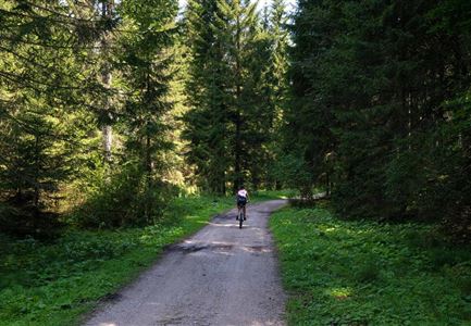
This tour starts at the citizen and tourism service. Follow the Römerweg in a more northern direction, through the underpass, further on to the Auländer Dorfstraße. At the junction opposite the small chapel, turn left and follow the Mühlbergweg downhill. As soon as the path joins the Möslweg, turn left and follow the forest path along the Niederbach always downhill (very steep) through the beautiful pine forest until you meet the main road again in the small village of Eigenhofen.

Alpine emergency call:
Call: 140

Features & Characteristics

Start Point

Information office Reith

End Point

Eigenhofen-Zirl

Similar Tour Suggestions

Gravelbikerin fährt vom Gaistal Richtung Leutasch.jpg

Cycling

Bikeroute No. 5080 Rauthhütte

Length

5,00 km

Duration

01:20 h

Uphill

423 hm

Downhill

416 hm

Altitude

1601 hm

Difficulty

Hard

Gravelbiker bei der Wildmoosalm im Sommer

Cycling

Biketour No. 547 Wildmoos-Buchen

Length

8,80 km

Duration

00:25 h

Uphill

184 hm

Downhill

183 hm

Altitude

1346 hm

Difficulty

Medium

Katzenkopf (c) Anna Rieder

Cycling

Biketour No. 541 Katzenkopf-Fluder

Length

8,50 km

Duration

01:10 h

Uphill

259 hm

Altitude

1370 hm

Difficulty

Hard

Radfahrer unterwegs im Gaistal mit Blick auf die Leutascher Ache

Cycling

Biketour No. 552 Gaistal-Hochfeldern Alm

Length

20,20 km

Duration

02:00 h

Uphill

539 hm

Downhill

536 hm

Altitude

1733 hm

Difficulty

Hard

Seebensee mit Raeder im Vordergrund

Cycling

Biketour No. 551 Seebensee

Length

27,60 km

Duration

01:40 h

Uphill

561 hm

Downhill

557 hm

Altitude

1581 hm

Difficulty

Medium

Verbindung-Seefeld-Reith Pfarrhügel (c) Anna Rieder

Cycling

Bike-connection No. 5030 Seefeld-Reith

Length

10,20 km

Duration

00:35 h

Uphill

120 hm

Downhill

115 hm

Altitude

1193 hm

Difficulty

Easy

Muggenmoosalm bei Leutasch im Sommer - Drohnenaufnahme.jpg

Cycling

Biketour No. 5048 Muggenmoosalm

Length

14,80 km

Duration

01:45 h

Uphill

326 hm

Downhill

323 hm

Altitude

1370 hm

Difficulty

Medium

Pfarrkirche im Sommer - Moesern

Cycling

Biketour No. 5068 Mösern-Brunschkopf

Length

8,90 km

Duration

01:00 h

Uphill

281 hm

Altitude

1496 hm

Difficulty

Medium