We use cookies for your personalized browsing experience, to personalize content and ads, to provide social media features, and to analyze traffic to our website. We also share information about your use of our website with our social media, advertising and analytics partners. Our partners may combine this information with other data that you have provided to them or that they have collected as part of your use of the Services. (incl. US providers)

Start Point

Bergstation Rosshütte

End Point

Bergstation Rosshütte

Difficulty

Easy

Total Distance

662 m

Descent Meters

28 m

Ascent Meters

24 m

Total Time

00:15 h

Map & Elevation Profile

Start Point

Bergstation Rosshütte

End Point

Bergstation Rosshütte

Difficulty

Easy

Total Distance

662 m

Descent Meters

28 m

Ascent Meters

24 m

Total Time

00:15 h

Hiking

Best Time

Jan

Feb

Mar

Apr

May

Jun

Jul

Aug

Sep

Oct

Nov

Dec

Hiking

Family holidays

+2

Route: Rosshütte mountain station - Stone Pine Trail - Rosshütte mountain station

Route description:

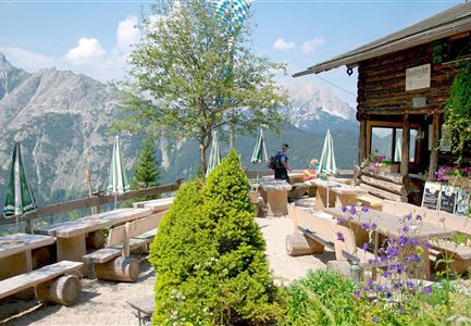
Above the Rosshütte mountain station, a 600m long path leads into the forest. Follow the circular hiking trail until you get back to the mountain station. Once there, the Rosshütte panorama restaurant is a good place to take a short break. 

Alpine emergency call & mountain rescue:

Tel.: 140

Features & Characteristics

Start Point

Bergstation Rosshütte

End Point

Bergstation Rosshütte

Family-friendly

Yes

Loop tour

Yes

Similar Tour Suggestions

Wandern zum Gasthof Brücke

Hiking

Tour of lawn "toler"

Length

4,20 km

Duration

00:45 h

Uphill

13 hm

Altitude

1072 hm

Difficulty

Easy

Wettersteinhuette (l) und Wangalm (r) im Wettersteingebirge (2).jpg

Hiking

Circular hike Wettersteinhütte alpine hut - Wangalm alpine hut - Hämmermoosalm alpine hut

Length

10,20 km

Duration

04:15 h

Uphill

562 hm

Altitude

1756 hm

Difficulty

Medium

Bikepause an der Isarquelle.jpg

Hiking

Bike & Hike Halleranger house - Halleranger alm

Length

38,00 km

Duration

06:00 h

Uphill

832 hm

Altitude

1768 hm

Difficulty

Medium

Isarursprung im Karwendel - Scharnitz (3).jpg

Hiking

Hike to the source of the river Isar & Kasten alpine hut

Length

28,20 km

Duration

06:00 h

Uphill

323 hm

Altitude

1227 hm

Difficulty

Easy

Kaltwassersee auf der Rosshütte über Seefeld

Hiking

Circular hiking traill to the Rosshütte alpine hut - Hochegg Alm alpine hut

Length

8,30 km

Duration

03:45 h

Uphill

515 hm

Altitude

1740 hm

Difficulty

Medium

Kurblhang

Hiking

Circular hike from Seefeld to Gießenbach & Leutasch

Length

21,50 km

Duration

06:30 h

Uphill

773 hm

Downhill

815 hm

Altitude

1616 hm

Difficulty

Medium

Sonnenuntergang über dem Inntal (Blick von der Friedensglocke - Querformat).jpg

Hiking

Jakobsweg Etappe 12: from Buchen to Telfs/Mötz

Length

23,70 km

Duration

06:00 h

Uphill

711 hm

Altitude

1310 hm

Difficulty

Medium

Reith im Frühling bei Morgenstimmung - Drohnenaufnahme Kirche mit Blick ins Inntal.jpg

Hiking

Cultural circular walking path Reith

Length

4,57 km

Duration

01:30 h

Uphill

113 hm

Altitude

1126 hm

Difficulty

Easy