We use cookies for your personalized browsing experience, to personalize content and ads, to provide social media features, and to analyze traffic to our website. We also share information about your use of our website with our social media, advertising and analytics partners. Our partners may combine this information with other data that you have provided to them or that they have collected as part of your use of the Services. (incl. US providers)

Start Point

Leutasch / Reindlau

End Point

Leutasch / Reindlau

Difficulty

Medium

Total Distance

13,00 km

Descent Meters

1352 m

Ascent Meters

36 m

Highest Point

2371 m

Total Time

09:00 h

Map & Elevation Profile

Start Point

Leutasch / Reindlau

End Point

Leutasch / Reindlau

Difficulty

Medium

Total Distance

13,00 km

Descent Meters

1352 m

Ascent Meters

36 m

Highest Point

2371 m

Total Time

09:00 h

Hiking

Best Time

Jan

Feb

Mar

Apr

May

Jun

Jul

Aug

Sep

Oct

Nov

Dec

Hiking tour

Hut hikes

Route: Leutasch / Reindlau – Meilerhütte - Leutasch / Reindlau

Public transport:

By train to Seefeld train station and continue with the Regiobus to the stop "Leutasch Reindlau".

Find all connections in real time with the Mobility-App "wegfinder".

Directions:

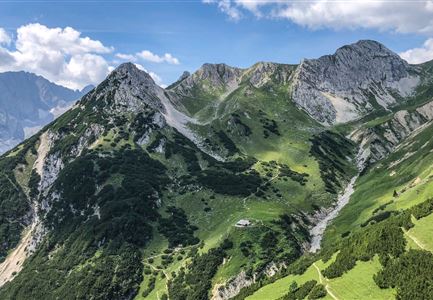
From Hubertushof in Reindlau, follow the road to the Bergleinbach stream. To the left along the stream, the trail leads into the Berglein valley and past under the walls of the Öfelekopf to the Meilerhütte. The descent follows the same route.

Alpine emergency call:

Call: 140

Features & Characteristics

Refreshment stops

Start Point

Leutasch / Reindlau

End Point

Leutasch / Reindlau

Similar Tour Suggestions

Schlossbachklamm mit Bahnstrecke - Reith.jpg

Hiking

Hike through the Schlossbachklamm

Length

12,20 km

Duration

04:30 h

Uphill

488 hm

Downhill

482 hm

Altitude

1129 hm

Difficulty

Easy

Friedensglocke im Herbst - Frau steht am Geländer und blickt ins Inntal beim Sonnenuntergang- Sonnenstern an der Glocke.jpg

Hiking

Peace Bell Hiking Trail

Length

4,60 km

Duration

01:30 h

Uphill

92 hm

Downhill

96 hm

Altitude

1292 hm

Difficulty

Easy

Durchs Karwendeltal aufs Karwendelhaus - Scharnitz

Hiking

Hike to the Karwendelhaus

Length

36,00 km

Duration

11:15 h

Uphill

839 hm

Altitude

1765 hm

Difficulty

Medium

Personen bei der Rotmoosalm im Sommer - auf der Terrasse (1).jpg

Hiking

Hike to the Rotmoosalm alpine hut

Length

9,00 km

Duration

05:30 h

Uphill

842 hm

Altitude

2037 hm

Difficulty

Medium

Wildmoosalm im Sommer - Alm aus der Distanz mit Gewässer im Vordergrund.jpg

Hiking

Circular hiking trail Wildmoos-Hochmoos

Length

10,00 km

Duration

04:00 h

Uphill

437 hm

Altitude

1544 hm

Difficulty

Medium

Gravelbike - Zum Isarursprung.jpg

Hiking

Bike & Hike Hoher Gleirsch Summit, 2,492 m

Length

31,00 km

Duration

09:30 h

Uphill

1772 hm

Altitude

2492 hm

Difficulty

Hard

Hallerangeralm

Hiking

Bike & Hike Sunntigerspitze Summit, 2,321 m

Length

42,00 km

Duration

09:00 h

Uphill

1396 hm

Altitude

2321 hm

Difficulty

Medium

Blick vom Predigtstuhl auf das Steinerne Huettl im Gaistal

Hiking

Bike & Hike to the Steinernes Hüttl alpine hut

Length

19,80 km

Duration

06:00 h

Uphill

1004 hm

Downhill

44 hm

Altitude

2131 hm

Difficulty

Medium