Start Point

Parking lot P2 'Stupfer' in Gaistal

End Point

Parking lot P2 'Stupfer' in Gaistal

Difficulty

Easy

Total Distance

10,30 km

Descent Meters

520 m

Ascent Meters

520 m

Highest Point

1721 m

Total Time

04:00 h

Map & Elevation Profile

Start Point

Parking lot P2 'Stupfer' in Gaistal

End Point

Parking lot P2 'Stupfer' in Gaistal

Difficulty

Easy

Total Distance

10,30 km

Descent Meters

520 m

Ascent Meters

520 m

Highest Point

1721 m

Total Time

04:00 h

Running

Best Time

Jan

Feb

Mar

Apr

May

Jun

Jul

Aug

Sep

Oct

Nov

Dec

Trailrunning

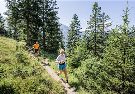
Starting from the paid parking lot P2 or the Leutasch-Stupfer bus stop, cross the Leutascher Ache upstream. After about a kilometer, cross the bridge and follow the trail to Hämmermoosalm. Here, after 2.5 kilometers and 200 meters of elevation gain, you can take your first break.

From the alm, follow the hiking trail to Rotmoosalm/Wettersteinhütte. The trail is a rooty path that ascends gently, offering many runnable sections. At Wettersteinhütte (after 6.5 kilometers), run down the forest road, and shortly before the parking lot, return to the starting point via the hiking trail.

Ambitious downhillers can take the forest path from Wettersteinhütte, though it offers few enjoyable running elements.

The indicated running time is a guideline and depends on personal fitness.

Features & Characteristics

Start Point

Parking lot P2 'Stupfer' in Gaistal

End Point

Parking lot P2 'Stupfer' in Gaistal

Similar Tour Suggestions

Schöne Aussicht vom Zäunlkopf.jpg

Running

Trail Run Loop to Oberbrunnalm via Zäunlkopf

Length

12,40 km

Duration

06:00 h

Uphill

880 hm

Altitude

1740 hm

Difficulty

Medium

Lärchenwald bei Reith_Wald mit Sonnenstern.jpg

Running

Around the Gschwandtkopf Trailrun Route

Length

10,30 km

Duration

02:00 h

Uphill

343 hm

Downhill

332 hm

Altitude

1334 hm

Difficulty

Easy

Trailrunning in der Region Seefeld - Läuferin auf dem Südwandsteig bergab.jpg

Running

Gaistal-Rotmoosalm Trail Run Loop

Length

15,00 km

Duration

06:30 h

Uphill

970 hm

Altitude

2133 hm

Difficulty

Medium

Trailrunning auf der Seefelder Spitze - Läufer rennt im Sonnenuntergang.jpg

Running

Leutasch Trail (Salomon Zugspitz Ultratrail)

Length

68,00 km

Duration

16:00 h

Uphill

2870 hm

Downhill

3370 hm

Altitude

2049 hm

Difficulty

Hard

Steg zum Wandern entlang der Gleirschklamm.jpg

Running

Trail Run Loop Isarsteig & Gleierschklamm

Length

12,40 km

Duration

04:00 h

Uphill

445 hm

Altitude

1250 hm

Difficulty

Easy

Nordic Summer Camp 2021 - Laeufer bei Laufrunde um den Moeserer See.jpg

Running

Trail Run Loop Möserer See

Length

9,20 km

Duration

02:00 h

Uphill

320 hm

Altitude

1500 hm

Difficulty

Easy

Trailrunning in der Region Seefeld - Läuferinnen auf Trail im Wald - Gaistal.jpg

Running

Steckenweg Trailrun-Route

Length

13,00 km

Duration

04:30 h

Uphill

480 hm

Altitude

1550 hm

Difficulty

Easy

Drohnenaufnahme Gaistal im Sommer - Sonnenaufgang Predigtstuhl - Blick Richtung Gehrenspitze.jpg

Running

Wetterstein Trail Run Loop

Length

25,00 km

Duration

10:30 h

Uphill

1490 hm

Altitude

2230 hm

Difficulty

Hard