We use cookies for your personalized browsing experience, to personalize content and ads, to provide social media features, and to analyze traffic to our website. We also share information about your use of our website with our social media, advertising and analytics partners. Our partners may combine this information with other data that you have provided to them or that they have collected as part of your use of the Services. (incl. US providers)

Start Point

Reith train station

End Point

Reith train station

Difficulty

Easy

Total Distance

6,70 km

Descent Meters

289 m

Ascent Meters

289 m

Highest Point

1306 m

Total Time

02:15 h

Map & Elevation Profile

Start Point

Reith train station

End Point

Reith train station

Difficulty

Easy

Total Distance

6,70 km

Descent Meters

289 m

Ascent Meters

289 m

Highest Point

1306 m

Total Time

02:15 h

Hiking

Best Time

Jan

Feb

Mar

Apr

May

Jun

Jul

Aug

Sep

Oct

Nov

Dec

Hiking tour

Circular hike

+2

Route: Reith train station - Kaiserstand - Rosenkranzweg - Frau Häusl Kapelle - Reith train station

Parking and public transport:

Parking facilities near the train station.

By train to Reith train station.

Find all connections in real time with the Mobility-App "wegfinder".

Directions:

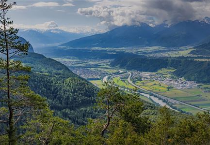
Starting from the train station Reith along the railroad line to the junction Nördlinger Hütte, from there the path turns right, along the panoramic path above Reith over the Hölltal to the Kaiserstand, where you can enjoy a magnificent view.

There are several ways back to Reith:

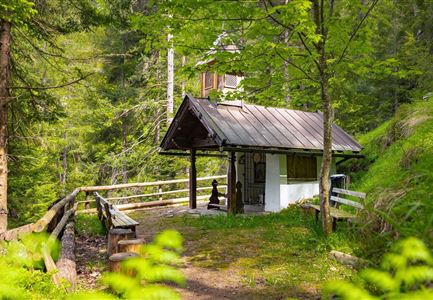
  • Variant 1 - as shown on the map: The same way back to the turnoff "Frau Häusl". This path leads to a small chapel with waterfall. From there, take the Rosenkranzweg (a path of contemplation with several wayside shrines) down to the village.

  • Variant 2: The same way back and back to the train station Reith.

  • Variant 3: The steep, over gravel and asphalt leading Kaiserstandweg down to the village.


Alpine emergency call:

Call: 140

Features & Characteristics

Start Point

Reith train station

End Point

Reith train station

Family-friendly

Yes

Loop tour

Yes

Similar Tour Suggestions

Scharnitz - Wanderung zur Adlerkanzel - Blick auf die Isar.jpg

Hiking

Circular village walk Scharnitz - Gießenbach

Length

6,10 km

Duration

01:30 h

Uphill

42 hm

Altitude

1013 hm

Difficulty

Easy

Wildmoosalm im Sommer - Hütte mit Kuh.jpg

Hiking

Hike to the Wildmoosalm alpine hut

Length

5,80 km

Duration

01:45 h

Uphill

131 hm

Altitude

1305 hm

Difficulty

Easy

Karwendelmarsch 2018 (13).jpg

Hiking

Karwendel March 35 km

Length

35,00 km

Duration

12:30 h

Uphill

1664 hm

Downhill

1358 hm

Altitude

1843 hm

Difficulty

Hard

Blumenwiese in Neuleutasch

Hiking

Hike from Leutasch to Seefeld

Length

4,60 km

Duration

01:30 h

Uphill

118 hm

Downhill

83 hm

Altitude

1225 hm

Difficulty

Easy

Muggenmoos-Muggenmoosalm (c) Anna Rieder

Hiking

Hike to the Muggenmoosalm alpine hut

Length

3,60 km

Duration

01:15 h

Uphill

80 hm

Altitude

1252 hm

Difficulty

Easy

Ahrn Hochfluder Weidach.jpg

Hiking

Hike Hoher Sattel

Length

10,60 km

Duration

04:00 h

Uphill

524 hm

Altitude

1620 hm

Difficulty

Medium

Drohnenaufnahme Aussichtsplattform auf dem Brunschkopf - Aufnahme bei Abenddämmerung mit Paar auf Plattform.jpg

Hiking

Viewpoint Brunschkopf via Möserer Höhe

Length

8,70 km

Duration

03:00 h

Uphill

311 hm

Downhill

314 hm

Altitude

1499 hm

Difficulty

Medium

Wildsee im Frühling bei Morgenstimmung - Drohnenaufnahme kleine Plattform am See.jpg

Hiking

Way of imperator Maximilian

Length

2,50 km

Duration

00:30 h

Uphill

3 hm

Altitude

1180 hm

Difficulty

Easy