We use cookies for your personalized browsing experience, to personalize content and ads, to provide social media features, and to analyze traffic to our website. We also share information about your use of our website with our social media, advertising and analytics partners. Our partners may combine this information with other data that you have provided to them or that they have collected as part of your use of the Services. (incl. US providers)

Start Point

Seefeld train station

End Point

Seefeld train station

Difficulty

Easy

Total Distance

9,30 km

Descent Meters

139 m

Ascent Meters

141 m

Highest Point

1199 m

Total Time

02:45 h

Map & Elevation Profile

Start Point

Seefeld train station

End Point

Seefeld train station

Difficulty

Easy

Total Distance

9,30 km

Descent Meters

139 m

Ascent Meters

141 m

Highest Point

1199 m

Total Time

02:45 h

Hiking

Best Time

Jan

Feb

Mar

Apr

May

Jun

Jul

Aug

Sep

Oct

Nov

Dec

Hiking

Hiking tour

+5

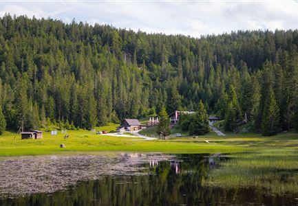
This circular hike leads through the small village of Reith, south of Seefeld, offering a picturesque route over the Reith Auland and around the Wildsee before returning to the starting point.

The hike begins directly at Seefeld train station. From there, turn left onto Reitherspitzstraße. Follow this road until it meets Römerweg, where you’ll turn right. Continue along Römerweg, Kreuzweg, and Lobaweg until you reach the commercial area by the main road.

Shortly after the small pond on Lobaweg, the route crosses the main road to the other side. It then continues along Reither Waldweg and the Bee Nature Trail, leading through green landscapes to the village square. Here, take Lauserweg down beside the Information Office. Along the way, the trail crosses the railway and main road via an underpass, eventually turning right onto Möslweg to begin the return journey.

Initially, the path follows part of a road before veering slightly left onto Gstoagweg, passing through the peaceful Reith Auland. After a bend, continue at Englhof Reith from Liftweg onto the forest path, which leads along the edge of the Auland meadows to the Wildsee promenade. Follow this stretch in its

Read More...

Features & Characteristics

Stamina

Technique

Start Point

Seefeld train station

End Point

Seefeld train station

Family-friendly

Yes

Stroller-friendly

Yes

Loop tour

Yes

Similar Tour Suggestions

Reither Spitze - Karwendel Hoehenweg Etappe 1

Hiking

Karwendel High Trial (Trail 1): Reith bei Seefeld - Nördlinger Hütte

Length

6,50 km

Duration

04:30 h

Uphill

1130 hm

Downhill

10 hm

Altitude

2239 hm

Difficulty

Medium

Wanderung zur Scharnitzer Alm - Scharnitzer Alm mit Tannenzweigen im Vordergrund.jpg

Hiking

Circular hiking trail Scharnitzer alpine hut

Length

5,70 km

Duration

01:30 h

Uphill

130 hm

Altitude

1022 hm

Difficulty

Easy

Familie vor dem Seekirchl im Sommer - 2.jpg

Hiking

Circular walk Seefeld to the Jumping hill

Length

2,00 km

Duration

00:30 h

Uphill

10 hm

Altitude

1195 hm

Difficulty

Easy

Reith - Wanderung Frau Häusl Kapelle - Bank und Bildstock mit Aussicht ins Inntal.jpg

Hiking

Circular hike panoramic path

Length

6,70 km

Duration

02:15 h

Uphill

289 hm

Altitude

1306 hm

Difficulty

Easy

Leutascher Geisterklamm - Wasserfallsteig (2).jpg

Hiking

​Hike through the Leutasch Spirit Gorge and to the Waterfall Trail

Length

5,00 km

Duration

02:30 h

Uphill

225 hm

Downhill

221 hm

Altitude

1061 hm

Difficulty

Medium

Closed
Meilerhütte

Hiking

Hike to the Meilerhütte alpine hut

Length

13,00 km

Duration

09:00 h

Uphill

1352 hm

Downhill

36 hm

Altitude

2371 hm

Difficulty

Medium

Bienenlehrpfad Reith - Infotafel am Bienenhotel (1).jpg

Hiking

Hiking bee trail

Length

2,50 km

Duration

01:00 h

Uphill

72 hm

Altitude

1185 hm

Difficulty

Easy

Lärchenwald in Reith - Drohnenaufnahme - Paar läuft zur den Wald - Aufnahme Richtung Sonne.jpg

Hiking

Round the Gschwandtkopf Hill (Circular Walk)

Length

10,60 km

Duration

03:30 h

Uphill

226 hm

Downhill

220 hm

Altitude

1344 hm

Difficulty

Easy